Quayside on old maps: 1574, 1688 and 1910
Three maps, drawn over some 340 years, show the same bend in the river beside the Great Bridge. Each mapmaker cared about different things, so none of them is a neutral record. Read together, they still tell you plenty.
1574: Richard Lyne's view
Lyne's engraving is closer to a picture than a survey. North is at the top, and the buildings are drawn as little standing blocks. Look at the top left for the castle, labelled "Castell", then follow the road down to "The Bredge".
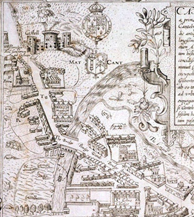
St Clement's church stands just below and to the right of the bridge, with a short row of houses reaching towards the water. That is roughly where Quayside lies today. Lyne doesn't name a quay or draw a wharf, and the river is far wider than it can ever have been here, so don't read too much into the detail.
What he does label clearly is "The kynges dicke", curling away to the right. The Latin panel on the map credits a ditch and gates to Henry III, in a year we read as about 1265, though the lettering is hard to make out. Modern archaeologists disagree. A 2017 excavation report puts the ditch's creation most probably in the 12th century. Perhaps Henry's men recut it, and his name stuck. We can't be sure.
1688: David Loggan's plan
Loggan's map appeared in his book of 1690, dated 1688 on the plate. It looks far more modern, being drawn from directly above, but it has a trap for modern readers: west is at the top. Tilt your head to the right to get north pointing upwards.
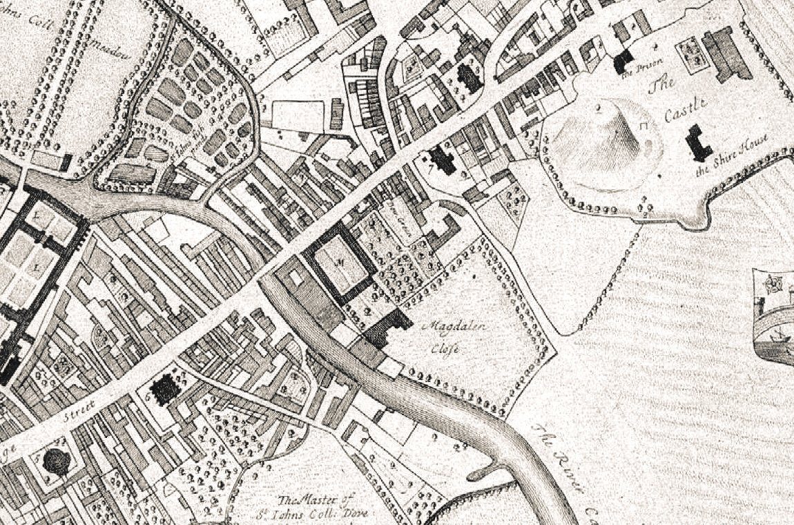
Bridge Street runs across the picture from bottom left to top right. Find where it crosses the river, then look below that point, on the near bank. Buildings crowd right up to the water there, which fits a working waterfront, though Loggan writes no name beside them. Opposite, Magdalene's courtyard is marked M, with "Magdalen Close" behind it.
Below the houses you can read "The Master of St. Johns Coll: Dove hous and fish ponds". St John's owned land off Thompson's Lane at this time, as excavation and college records confirm, so the river bank here wasn't all trade. Top right is the castle, with its mound, "the Prison" and "the Shire House".
1910: Conybeare's guidebook map
By 1910 we are looking at something a tourist could use. This map comes from Edward Conybeare's Highways and Byways in Cambridge and Ely. North is at the top again.
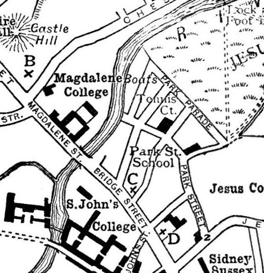
One word does a lot of work here: "Boats", printed beside the river just downstream of the bridge. Conybeare's map doesn't say whose boats, or of what kind. Still, it's a useful date to have, a few years after pleasure punts first appeared on the Cam. Cargo was nearly finished, and boats for hire were moving in.
Compare the three and one thing stays put: the river's sharp bend beside the bridge. The 2017 report explains why. The local geology pinches the Cam at this spot, forcing the river to arc east, which may also have helped make it a crossing point.
What the maps can't tell you
None of them marks the medieval hythes by name, so they can't settle where the common hythe stood. Nor should you rely on them for fine detail. Mapmakers copied, tidied and flattered, and a Queens' College history points out errors in how early maps placed its own bridges.
Sources
- Richard Lyne, map of Cambridge, 1574, as reproduced on Wikimedia Commons. The reading of the Latin panel is our own.
- David Loggan, Cantabrigia Illustrata, 1690, as reproduced on Wikimedia Commons.
- Edward Conybeare, Highways and Byways in Cambridge and Ely, 1910, as reproduced on Wikimedia Commons.
- Craig Cessford, excavations at WYNG Gardens, Thompson's Lane, Proceedings of the Cambridge Antiquarian Society, 2017. Used for the King's Ditch, St John's ownership and the river's geology.
- Queens' College, Old views and plans. Used for errors on early maps.
Checked October 2026. Our notes on what the maps show are our own reading of them.
The story behind the maps
Read about the trade that made this bank busy.